Wednesday, December 24, 2008

Puerto Rico: Motoring the South Coast

Boqueron: After our rides to Mayaguez to check into the country, we were ready for some well-deserved rest. The following day, we explored the little town with its quiet streets, empty food stalls (full of scallops during the weekend), friendly people and working high speed internet! Boqueron would become our favourite place along the South Coast, but that might have to do with the feeling of finally being back in civilization with all its conveniences, mixed with the relaxed atmosphere of a Latin American country. The town is clean, the bay calm and pretty. The park with palm trees and a big, yellow beach is attractive, but … dogs are not allowed. We realized later that Puerto Rico is not the greatest place for our “kids”. Stray dogs are aggressive, most beaches don’t allow dogs and in Ponce, we almost got a fine for not having muzzles on Kali and Darwin while walking them, on leash, through a pedestrian zone!

Cabo Rojo: The motor trip continued, since we were still headed into the wind. Before we rounded the cape on the south western corner of Puerto Rico, we saw a cute lighthouse on the top of a cliff and decided we were not in a hurry to get to La Parguera, our next destination. We knew going east would be slow and a bit uncomfortable as it was, but we also wanted to see a few things along the way. After a hot hike to the top of the cliff, where the lighthouse and a great view awaited, we found a surprisingly packed white beach in a pretty cove. Our dip in the clear water was very refreshing – it surely had been a while- and all four of us enjoyed the stop.


La Parguera: A lot of people rave about this town in the mangroves. We have no idea why… Everything on land is built in and out and on concrete. No grass to be found, let alone a beach. Mark and I explored different bays with our dinghy and followed a canal with a natural roof of mangroves, which was pretty cool. Some of the wooden houses on the water stand on stilts and are colourful. Very cute! We also did a little tour to a bioluminescent bay, but were not impressed. There is a lot of light pollution. Our experiences with the phosphorescent water in Luperon were more special. Weather kept us there for a couple of days, but right after that, we moved on.


Gilligan’s Island: We got pretty lucky with the benign winds while we travelled along the coast. Once again, for each leg, we needed to leave in the dark, to reach our next destination before the wind would pick up in early morning. On calm days, we decided to travel during the day without being beaten up too badly. One of those days, we arrived near Gilligan’s Island in the afternoon. The attraction there is a clear lagoon in the mangroves. It is located in a
National Park (no dogs allowed). When Mark and I checked it out, the prettiness was lost because of the dark clouds overhead.


Ponce: The anchorage in Ponce is nothing special. The water is deep; the shallower spots are taken by private mooring balls. The surroundings of the bay are industrial on one side, private on the other side with the Yacht Club, and a wooden board walk with kiosks on the third side. This area is busy during the weekends and quiet on other days. A lot of police is present any time. This is also the area where we could leave our dinghy at a public boat ramp. We had to walk passed the board walk to get to a run down public beach area, where at last, the dogs could run freely. The main reason we stopped in Ponce was to pick up a few packages and to rent a car to do grocery shopping and boat provisioning. The day we rented the car, we sneaked a short visit to the historic center in.


Isla Cajo de Muertos: This island on the way to Salinas has a gorgeous Bahama-like anchorage. We spent the night in beautiful blue and clear water, while we looked out over a lighthouse and an arid, deserted island. I walked the tricky and prickly trail, lined with brush and huge cacti, up the hill, where the neglected lighthouse was situated. Mark stayed low key on the beach. If we would have known no rangers resided on the island, we could have taken the dogs with us on the hike, because, of course, no dogs were allowed on the island.


Salinas: The best hurricane hole in Puerto Rico is near here. The bay next to Playa Salinas is also very protected and inhabited by manatees. We weren’t lucky enough to see these mellow clumsy creatures yet, but got a glimpse of them in our next anchorage. Salinas didn’t do it for us, either. People are still very friendly and we are very grateful that the marina lets cruisers use the dinghy dock, water and garbage cans. The real town is a bit of a walk and that’s were the post office and the big grocery store are located. Before we came to Puerto Rico, we expected it to be not too different than an American State. The postal system is the same, so it would be easy for us to order stuff online and pick it up. We thought! The hassle we had to go through to deal with all the packages was huge. Orders were sent to the wrong address, got delayed, weren’t allowed to be forwarded, were back ordered, or got sent the wrong way even though we requested them to go USPS (of course we didn’t have an address for all those FedEx and UPS packages), which caused us most of the trouble. It was a frustrating mess and might have to do with our less than happy moods while dealing with all this for a month. On top of that, we didn’t have a phone to call and check in on statuses or to fix the problems. We tried to get Mark’s American phone to work, but even that turned into a three week endeavour with no luck so we gave up.


Punta Patillas: The trips from Salinas on were tricky and caused contradiction. We needed to leave in the dark to make progress, but… fish traps with floats on the water surface were spread all over the place. We needed enough light to be able to see and avoid them. Even then, they were hard to see because of the choppy seas. Since spotting them a few times unexpectedly, we never left before day break anymore. Our last stop on the South Coast, was the clear bay at Punta Patillas. We took advantage of the visibility of the water, to scrub the bottom of our boat once more. The amount of crap that had collected again was unbelievable! We also noticed a big chunk was missing out of one propeller and the other one was deteriorating as well. Our list of stuff to do on the boat was still growing! We counted on doing a lot of work on Irie, so it was no surprise that our visit to Puerto Rico would be one of pleasure ánd work. How much work, would become clear, once we anchored on the East Coast of the country.

Thursday, December 18, 2008

Crossing the Mona Passage

The area between the Dominican Republic and Puerto Rico is called the Mona Passage. It is a body of water getting squeezed between the two countries. All of a sudden the Caribbean Ocean narrows down into the Atlantic or visa versa. That’s a lot of turbulent water. Add some current and many shallow areas that need avoidance and that influence the surrounding water and you get interesting seas, only to be battled in times of decent weather conditions: low swells (waves) and little wind (less then 15 knots).


The day Irie left Punta Macao, our last stop in the Dominican Republic, the weather forecast was a little iffy. Once we were “out there”, the ocean and wind felt much better than the previous day. The water was still pretty choppy, but we decided to keep on going. Some people in Luperon had checked the weather online and this information got relayed to us by our friends Al and Gail from Chickadee. They were still in the anchorage and would leave around midnight. The wind came out of the North East, pretty rare and quite bothersome the first 9 hours, since we had to motor straight into it. After midnight, the hardest part was over. We heard later that Chicadee had to leave earlier because the anchorage in Punta Macao became dangerous in winds with a Northerly component. When Irie changed direction, the wind became our friend once again. It had been a long time! An almost full moon guided us through the passage and we managed to sail from here on, all the way past Isla Desechio, dodging a few rain clouds.


Once we passed this island, we decided to head for Boqueron. We read that you have to check into Puerto Rico in person, in the customs building of Mayaguez. This is a big and uncomfortable industrial harbour, where we didn’t want to stay or rest up. So we risked it and moved on, hoping we could check in by phone since we are both “Americans” and we had heard from others doing this and succeeding. We were sailing along and all of a sudden a police boat hovered over us. Mark had already talked to the Coast Guard who flew over us by plane before. The police were checking us out and following us. After a while, they made radio contact and we gave them all our information. For another 15 minutes, they followed us, close by. Then, they sped off, putting those four huge outboard engines to good use!


About three hours later, when we came closer to shore, another police boat showed up. Same scenario, but this one didn’t like using the radio, so the conversation happened with screaming voices in Spanish, while we were alongside each other. Luckily, this was the extend of it. Al and Gail arrived at night and they had a police boat sneak up behind them, all of a sudden shining a huge beam of light into their cockpit. Over the next few days, we had several boats checking us out in different anchorages. Once, we woke up from a light entering Irie. We ignored their presence and never had any other conversations with them anymore.


Around 1 pm, after 20 hours on the water, we arrived at our destination. The bay in Boqueron looked really nice. There were quite a few boats, but no other cruisers. A huge beach lined with palm trees took up part of the shoreline. From the moment we were settled, Mark got off and called US Customs. No luck… We had to go to Mayaguez in person. Now. All we wanted to do was take a nap, but we knew about the risk involved. Our bad. First, we did “sneak” the dogs ashore, though, to let them go potty. Kali has been really good about peeing on the trampoline, but Darwin still refuses if he can hold it.


There is a guy in Boqueron that can bring you to the Customs building and back fro $15 a person. The other options to get to Mayaguez are to wait around for one of the infrequent publicos or to hitch hike. We ended up using a combination of the two. We were hitch hiking, when a publico showed up and for $3 the two of us reached the next town. From there, a friendly mum and her crazy (literally!) son dropped us off at the pink Customs building. The formalities didn’t take very long (hey, I have a greencard now), the wait for a lift back unfortunately did. We had to walk a fair amount, before another crazy driver stopped and actually brought us all the way back to the harbour of Boqueron. That was very nice of him, so we paid him some money. By the time we arrived back on Irie, it was too late for a nap, so we just went to sleep…

Monday, December 1, 2008

Easting: Easy or not?

Sailing in the Caribbean can be a lot of fun, except when you want to go east. And, that’s exactly what you have to do to get there and around. The route to go east in this region is called the “thorny Path”. For most people this path starts in the Dominican Republic, the point where you want to start heading east to reach the beautiful islands. There is a way to make the trip “Thornless”, if you follow a certain procedure. We all know about this tactic, because of the author Bruce Van Sant (www.luperoncruising.com), who wrote the book “Passages South”. Mark and I met Bruce in Luperon, where he lives with his wife Rosa.

Going east is difficult, because this is the direction of the trade winds. They normally blow very steady, every day, between 15 and 20 knots, from an easterly direction. Sailing is impossible, unless you tack (zig zag) back and forth, going twice the distance and needing twice the amount of time to get somewhere. You also need a lot of sea room toward your destination to make the stretches back and forth worthwhile and the further you are off shore, the bigger the waves. The only solution is to motor or motor sail (with the main sail up, only possible when your course is not dead into the wind). Ideal circumstances to motor are no wind and no swell (waves from the sea, not from the wind). Since these conditions are very rare, especially together, one needs to wait until the wind is pretty light (under 15 knots) and the waves are benign (less than 5 feet). When this situation happens, we have a “weather window”, meaning: it’s time to GO! The longer the weather window, the longer (and further) you can go east.

Another important effect is called the “lee of the land”. At night, when the land cools off, the wind along the shores stops. Sometimes, when it was a very calm day, the breeze can come from the land instead of the sea. The less wind during the day, the bigger the chances of a “lee of the land”-effect and the further out to sea this effect takes place. Confusing enough? It basically comes down to waiting until the wind and the swell subside and travelling at night, because motoring into the wind and waves is very uncomfortable for humans and dogs (getting thrown up and down, left and right, getting sea sick), takes a beating on the boat (things will brake) and requires a lot of fuel (expensive). That’s why we all try to follow Bruce’s advice…

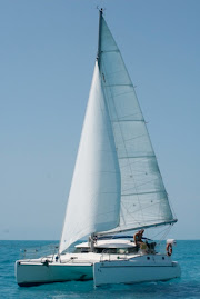
Irie left Luperon on November 5th around 6 pm, when the sun just set. Luckily, there was still enough light for us to see the fish traps near the entrance of the harbour. Our first night trip was very tiring, since we were not used to this new rhythm yet. I had a hard time keeping my eyes open during the three hour shifts. We reached Rio San Juan before daylight and steered towards the ocean for half an hour. By the time we turned back, there was enough light to enter the anchorage. The place was a bit tricky, since it is surrounded by reefs and we didn’t have a good chart (map) of the area. The swell coming into the anchorage made it a bit hard to do things on the boat and to take the dogs to shore. Luckily, it all worked out fine. We all got some rest, Kali and Darwin did there business and around 5pm, we packed up again.

This time, our destination was Samana, the last big port of importance in the Dominican Republic. We hoped to be far enough off shore to avoid fish traps, but yet be close enough to stay clear of the “garbage line” and benefit from the land effect. The sea was very calm and we made good progress towards our destination. During Mark’s first shift, he had a pretty good scare. At one point, he thought he heard an engine, but he couldn’t see anything. He ended up just missing a little fishing boat, without any lights on. That experience made me very alert during my shift. If only we had some moon that night!

We arrived in Samana, arranged all the “check-in procedures” ($15 harbour fee) and decided to treat ourselves with a real night of sleep in the harbour. The weather window when we left Luperon had called for at least a week of good conditions. Mark checked it all again in Samana, we explored town a bit and had our last meal out to spend the rest of our pesos. The next afternoon, we checked out of the country ($20) and left for a small bay, called Punta Macao. This is still in the Dominican Republic, but not much is there. Al and Gail, people we knew from Luperon, went the same way in their sailboat “Our Lil’ Chickadee”.

When we entered the “harbour” of Punta Macao, Bruce’s book had us go over a few shallower areas. It wasn’t a problem… that day. The bay was pretty rolly and not really a good place to be for an extended period of time. The scenery and the water were beautiful, though, making this one of our favourite places in the country. Mark and I had planned to let the dogs off the boat for a while (the reason of this stop) and rest up for a few hours, before leaving again the same day. Al and Gail convinced us to wait until the next morning, which is also recommended in the book. The crossing to Puerto Rico would take between 16 and 24 hours in good conditions, basically a day and a night. Because of the swell coming into the anchorage, it was a challenge to take the dogs (and ourselves; we witnessed Al and Gail capsize during their try) to shore, but we managed.

The next morning, our adrenaline got going. We took the dogs to shore at 5 am, not being able to estimate the waves crashing on the high tide and disappearing beach in front of the rocks, because it was pitch black. We got lucky and not too soaked. The dogs were very obedient, doing their business quickly on command. We rushed back out into the waves, took the engine of the dinghy and hauled both onto the bopping boat. Then, we waited a bit for a shiver of light. At 6 am, we lifted anchor and headed out of the bay. Where the water was shallower, the waves were breaking! We pushed through and crashed into them. Irie banged up and down and wasn’t happy. This was the first sign of a rough sea and a heavy wind out in the open. We stuck our nose into the ocean, to find high waves and confused seas. What to do? This was not predicted!

For another hour, we ploughed through the water, hoping it would get better soon. The wind was blowing 17 knots, the waves were about 7 feet high. This was the Mona Passage. You want to cross it in “ideal” conditions, because the area is already tricky without adding weather features to it. In our situation, the conditions were just slightly off and a bit uncomfortable. We’ve had this happen before and managed to deal with it, but now we were talking about being uncomfortable for 20 hours, wasting a lot of fuel and beating up the boat. It was our choice, and a difficult one. “Chickadee” had already turned back. We followed their example and sailed quickly, with the wind behind us, back to Punta Macao. It took us half the time! Of course, we had to pass the shallow areas again. This time with the waves behind us. One of the breakers picked us up and pushed us way into the bay. Irie was surfing! Exhilarating for me, frightening for Mark. We did 12 knots! Luckily, our bow didn’t dig into the water (we could have flipped) and the area got deeper again, so we didn’t run into a reef or the beach and the wave mellowed out. Al and Gail asked later how the hell we got in so quickly behind them…

The weather had turned on us. We listened carefully to all the predictions and it seemed to get worse and worse the longer we waited. The swell would also come from the north later on, making Punta Macao a dangerous place to be. We had to make a decision soon… The next day, Irie left in the afternoon, taking a little bit of a risk with the weather and hoping the NWS (NOAA) weather men were wrong. Al got in touch via the SSB radio with people in Luperon, who came back –after checking on the internet and talking to Bruce- with the positive news of the Mona Passage being “open”, meaning decent crossing conditions for another 36 hours. We called Al on our VHF radio right before we were getting gout of reach. When he told us the news, a big sigh of relief was heard on Irie. We would keep going this time. The weather men were wrong (for now). Chickadee planned on leaving the next morning. Later, we found out they left six hours after us. The wind and swell had turned north east, waves were breaking profusely over the shallows and reefs and soon after, it would have been impossible to even leave the anchorage of Punta Macao. We made the right decision!